A walk from the pretty village of East Garston through farmland and the Berkshire Downs with stunning views; ever-present horse racing country and fascinating geology.
Useful Info
- 4 miles / 6.5 km
- Start point: East Garston village hall/Social club
- What3words: ///powers.exacted.ooze
- Grid Ref: SU363767
- OS Explorer Map: 158 Newbury & Hungerford
- Park at the village hall or considerately on roads in the village.
- Buses between Newbury and Lambourn stop at Humphrey’s Lane, a short walk into the village, see Newbury and District bus website for information.
- Some steep climbs, no stiles, 1 kissing gate. Can be muddy, high vegetation including nettles in the summer
- Pub: The Queens Arms, East Garston
- GPX: Click here to download
Route Directions
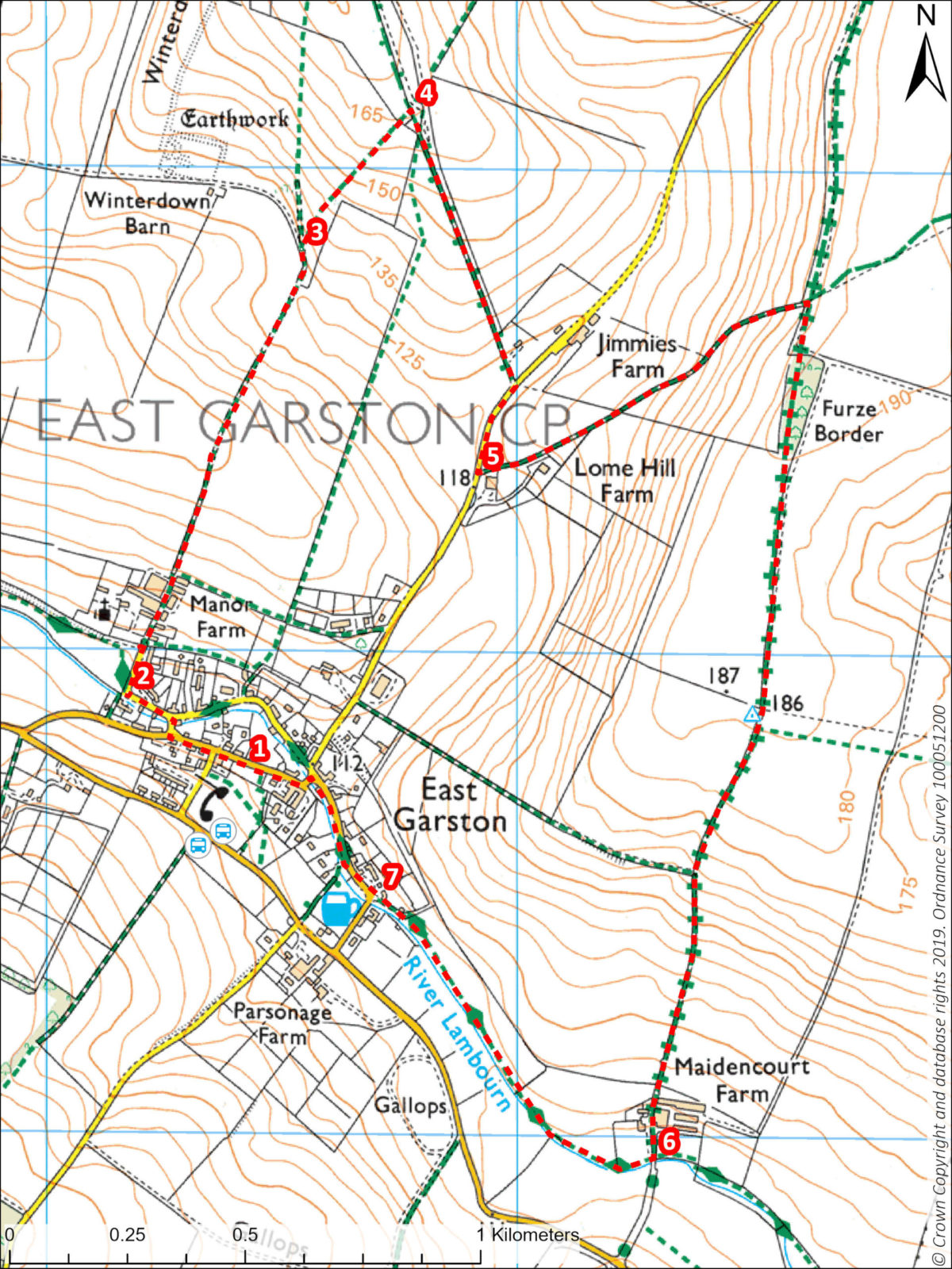
- With your back to the village hall/Social club, walk left along Back Street, turn right at the war memorial. Cross the River Lambourn and bear left along Station Road.
- After about 100 m follow the road bearing right. All Saints Church can be seen on your left. (you may want to detour to see a fine example of an 18th century cob wall, north of the churchyard). Continue straight ahead uphill on a surfaced track. Pass Manor Farm and follow the footpath over a ridge for about 800m.
- Take a signed footpath off to the right up a steep bank into open fields.
- At the top of the hill go through two gates then turn immediately right along the fence line onto a path between hedges with bollards with a caution sign. Follow this path downhill to Jimmies Farm, then turn right onto the road.
- After 100 metres, take a path left at a barn and walk uphill between two hedges. At the top of the steep hill turn right onto a byway and follow this all the way to Maidencourt Farm.
- After the farm buildings turn right at the River (Lambourn Valley Way). Go through a kissing gate and walk alongside the river back to East Garston. (The footpath follows the line of the Lambourn Valley Railway, which connected with the mainline Devon to London line until 1960.)
- The path emerges on a bend on Front Road. Walk straight ahead back to the village. At the village centre, cross the river onto Back Street and back to the village hall.
Points of Interest
- East Garston has many fine buildings constructed from local materials include flint, sarsens, chalk, brick and tile. The soil on the higher parts of the slopes around Jimmy’s Farm and Furze Border are dark and reddish-brown being clay-with-flints. Material from here was probably used for some of the early brick building in the village. For more information about the geology of the area, see https://berksgeoconservation.org.uk/
- During the Ice Age, meltwater cut into the hillside forming the characteristic chalk downland and streams of Southern England. Chalk landscapes are rare worldwide and home to specialist chalk species, such as orchids. The upper reaches of the River Lambourn are seasonal, fed by a chalk aquifer from springs upstream of the village; this is called a Winterborne stream.


